 Join WhatsApp Channel

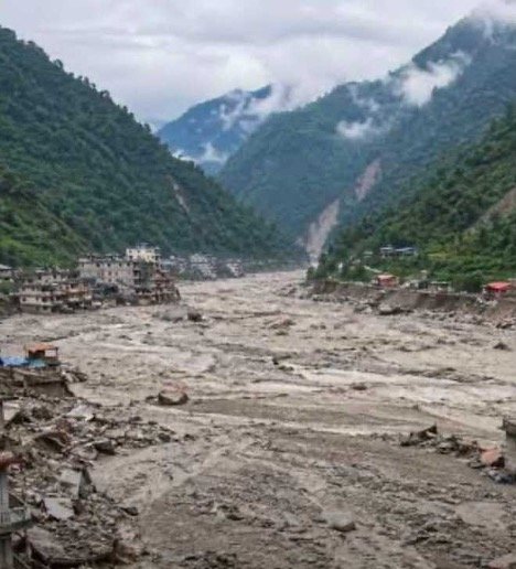
The deadly glacier burst in Tibet, which triggered a wall of water and mud to drown the narrow gorges of the Bhote Kosi River in neighboring Nepal, has intensified scrutiny of China’s construction and dam building activity on the roof of the world.
Construction in the highly fragile Himalayas can cause erosion, trigger earthquakes and landslides, and set off a chain of ecological events from glacier bursts to snow avalanches, which in turn can cause floods and a whirlwind of destruction downstream.
The magnitude 4.4 earthquake in Tibet in the early hours of Wednesday may or may not have caused the glacial burst which drowned Nepali towns and villages, the fact remains that China has been building a series of militarized concrete villages and towns in the fragile Himalayas, along with missile silos, connecting roads and military airports, throughout the Tibetan part of the Himalayas, which has been recorded by numerous satellite imagery.
Last year, China also started building the massive USD 170 billion hydroelectric power project and dam on the Yarlung Tsangpo River near the border with India’s Arunachal Pradesh. This dam, once finished, is expected to generate 300 billion kilowatt-hours of electricity and will be the largest single hydropower project in the world.
The danger it poses downstream in the case of a disaster is obviously something that all the regions through which water flows should be wary of. The Yarlung Tsangpo River flows and connects to the Siang River in Arunachal Pradesh’s Gelling to move into Assam as the Brahmaputra, after being connected by more rivers. The entire Himalayan belt is a seismically high-risk zone. Scientists at Caltech and ISRO have identified four specific segments in the 2,000 km-long Himalayan arch where seismic activity is building up enormous stress, which can trigger earthquakes.
The danger of a seismic event occurring, triggered by the huge construction activity in the high Himalayas, could possibly lead to a chain reaction triggering a dam burst with devastating effects on the lower riparian nations of India and Bangladesh, as the Brahmaputra flows downstream from Assam into Bangladesh to join the mighty Padma before emptying into the Bay of Bengal.
The Brahmaputra basin already suffers from high sediment loads, steep gradients, and seismic activity of its own; any shock flood carrying the debris of a very large upstream structure can magnify downstream vulnerability in Assam, Arunachal Pradesh and, further on, Bangladesh.
According to reports published earlier this year by the South China Morning Post, warnings that the giant hydroelectric project sits on a seismic fault line have been made by Chinese geologists themselves.
A Chinese-language journal, Sedimentary Geology and Tethyan Geology, has also said engineers have been advised to take steps to mitigate the risk of landslides and collapses.
Other researchers have flagged the possibility of reservoir triggered seismicity (RTS), where the weight of stored water itself causes stress on underlying faults and induces earthquakes.
Indian officials say that “Even without failure, the dam gives China significant operational control over a large share of the river’s flow. And the possibility of weaponizing water at a later stage is something which cannot be ruled out.”
What compounds the problem for India is that China has not shared hydrological data on the Yarlung Tsangpo and other rivers originating in Tibet with lower riparian states, whether they are India or Nepal, or, for that matter, Bangladesh, which is politically closest to China at this point of time.
Related posts:
 Opinion: Pakistan’s Fake Narrative Against India to Hide its Own Mismanagement of Water Resources
Facts Versus Fabrication: Reassessing the Indus Basin Water Debate
Opinion: Pakistan’s Fake Narrative Against India to Hide its Own Mismanagement of Water Resources
Facts Versus Fabrication: Reassessing the Indus Basin Water Debate
 Tibetans to Hold Nationwide Protests on August 20 Over New Chinese Law Which ‘Attacks Ethnic Rights’
 Climate’s Missing Link: Earth’s Core as Climate Change Accelerator
