
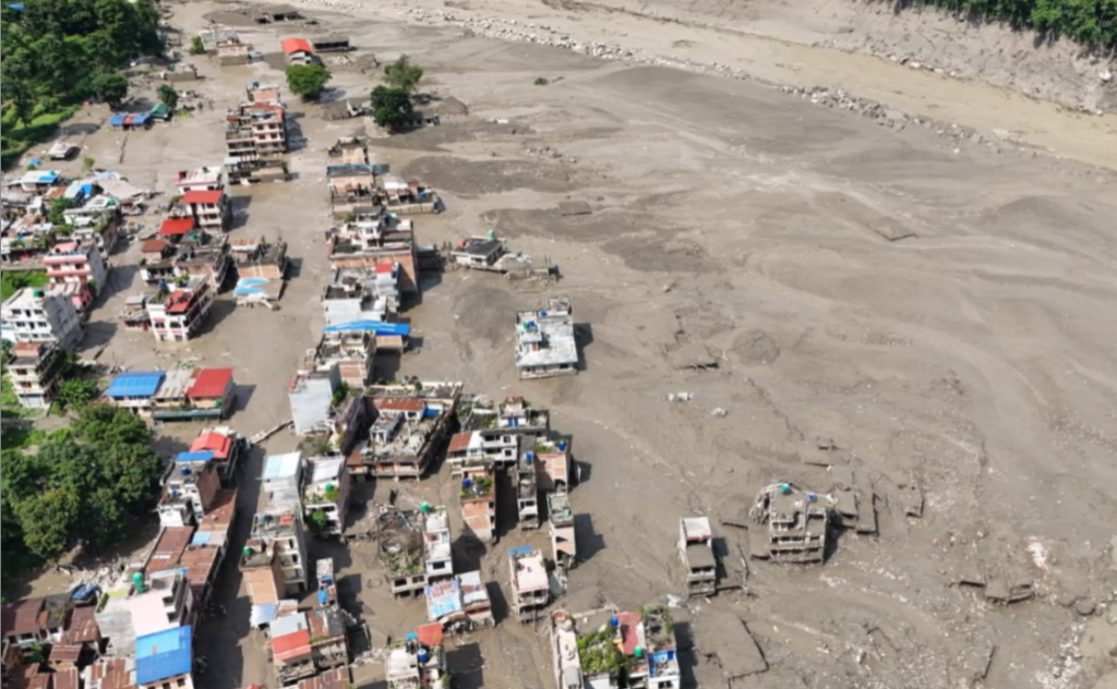
A major flash flood that tore through Nepal’s Rasuwa district on August 26 has exposed a rapidly evolving Himalayan risk: disasters originating high above the river valleys can now cascade into destructive floods within minutes, leaving conventional warning systems and infrastructure planning struggling to keep pace.
The flood sent water, sediment and boulders through the Bhote Koshi and Trishuli river systems after water levels began rising rapidly at about 9 a.m., with the surge travelling downstream towards Nuwakot and Dhading. The speed was exceptional: the Trishuli River at Galchchi reportedly rose by as much as nine metres in 30 minutes, while levels at Malekhu increased by seven meters over a similar period.
Scientists from the International Centre for Integrated Mountain Development (ICIMOD) and partner institutions in Nepal and China are investigating whether an ice-rock avalanche from a high-altitude area triggered the event. Preliminary assessments suggest that a large volume of ice and rock may have entered the Lende Khola, a tributary of the Bhote Koshi, producing a sudden wave of water, sediment and boulders.
The precise trigger remains unconfirmed, and scientists are also examining whether debris temporarily blocked the river, creating a landslide dam whose eventual failure could have amplified the downstream flood.
Advertisement
“The Lhende Khola has flooded twice in fourteen months, this time most probably triggered by an ice avalanche [that] blocked the river and released a sudden surge downstream,” said Saswata Sanyal, Disaster Risk Reduction Specialist at ICIMOD. “These are cascading hazards: a cryosphere event becomes a flood in a settlement within hours.”
That description may prove more important than the immediate cause of the disaster. Himalayan risk is increasingly becoming a chain reaction rather than a single hazard: an avalanche can generate a landslide, the landslide can block a river, the blockage can create an unstable lake, and its failure can send a debris-laden torrent into densely populated valleys.
Several monitoring stations along the Trishuli were damaged or washed away, highlighting another vulnerability: the very infrastructure required to understand a rapidly changing river system can itself be destroyed by the event it is intended to monitor.
Unusual seismic signals recorded by stations at Jilong, about 12 kilometres from the affected area, and Zhangmu have also been identified around the time of the suspected avalanche. A magnitude 5.2 earthquake was recorded by the US Geological Survey in the region, but scientists have not established a causal relationship between seismic activity and the flood.
The uncertainty underscores the difficulty of managing a landscape in which multiple hazards can interact. Climate change is altering glaciers, snow conditions, permafrost and mountain slopes across the Hindu Kush Himalaya, but ICIMOD has cautioned that it is too early to determine how much of a role climate change played in this particular event.
The broader trend, however, is harder to dismiss.
“The increasing frequency of cryosphere hazards is becoming more visible than ever before. The pace of change is so rapid that current efforts are struggling to keep up,” said Mohd. Farooq Azam, Senior Cryosphere Specialist at ICIMOD. He called for stronger regional collaboration and coordinated government action on cross-border hazards.
The implications extend well beyond Rasuwa. The Bhote Koshi originates in Tibet before entering Nepal, while the Trishuli is part of a river network whose hazards can affect communities, infrastructure and economic activity far downstream. The latest event therefore demonstrates that disaster preparedness cannot remain confined within administrative or national boundaries.
Indeed, the most immediate concern may be the possibility of secondary flooding. Qianggong Zhang, Head of Climate and Environmental Risks at ICIMOD, said the same area devastated by last year’s Rasuwa flood was again under threat, with a suspected ice avalanche in the Lhende Khola and a blockage remaining upstream near the Nepal-China border. Authorities warned of a possible second flood and ordered evacuations at Jilong port.
The problem is not simply a shortage of information. It is the gap between information and action.
“What we saw in the Lhende Khola is truly a catastrophe,” said Neera Shrestha Pradhan, Water and Disaster Risk Reduction Lead at ICIMOD. She pointed to community-based warning systems in the Hindu Kush Himalaya, where upstream communities relay information downstream, but argued that a cross-border warning mechanism would be especially valuable in this case.
“Providing information alone is not enough,” she said, stressing that communities must know how to interpret warnings and act without panic.
That institutional gap is becoming increasingly consequential as development expands into fragile mountain corridors. Roads, bridges, hydropower plants, settlements and transmission infrastructure are often concentrated beside rivers because steep Himalayan terrain leaves limited alternatives. Yet infrastructure designed around conventional flood probabilities can be badly exposed to debris flows whose speed, volume and destructive force are fundamentally different from rainfall-driven flooding.
Basanta Raj Adhikari, Director of the Centre for Disaster Studies at Tribhuvan University, said the exposure profile of communities in Rasuwa and Betrawati is “changing dramatically,” making real-time risk information essential for local decision-makers.
For Nepal, India and China, the strategic lesson is increasingly clear: Himalayan disaster management must evolve from isolated flood forecasting towards integrated, cross-border monitoring of glaciers, slopes, seismic activity, river levels and potential landslide dams.
That will require investment in satellite surveillance, high-altitude sensors, resilient river gauges and community-level warning networks, but technology alone will not solve the problem. Governments will also have to rethink where infrastructure is built, how projects are assessed and whether existing risk maps remain valid as mountain conditions change.
The August 26 flood is therefore more than a disaster requiring reconstruction. It is a test of whether Himalayan governments can anticipate a future in which hazards increasingly interact faster than institutions can respond.
As Adhikari put it, real-time risk information must reach those making decisions on the ground and “translate into life-saving decisions.”
The question for the coming years is whether that translation will happen before the next mountain breaks.